


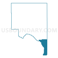
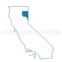
Voting District 50100, Lassen County, California
About
Outline

Summary
| Unique Area Identifier | 532502 |
| Name | Voting District 50100 |
| County | Lassen County |
| State | California |
| Area (square miles) | 265.68 |
| Land Area (square miles) | 263.59 |
| Water Area (square miles) | 2.09 |
| % of Land Area | 99.21 |
| % of Water Area | 0.79 |
| Latitude of the Internal Point | 39.97449950 |
| Longtitude of the Internal Point | -120.09010100 |
Maps

Graphs
Select a template below for downloading or customizing gragh for Voting District 50100, Lassen County, California


Neighbors
Neighoring Voting District (by Name) Neighboring Voting District on the Map
- Voting District 10010, Plumas County, CA
- Voting District 20020, Plumas County, CA
- Voting District 30050, Lassen County, CA
- Voting District 40000, Sierra County, CA
- Voting District 50115, Lassen County, CA
- Voting District 50125, Lassen County, CA
- Precinct No. 7519, Washoe County, NV
- Precinct No. 7536, Washoe County, NV
- Precinct No. 7547, Washoe County, NV
- Precinct No. 7552, Washoe County, NV
Top 10 Neighboring County Subdivision (by Population) Neighboring County Subdivision on the Map
- North Valleys CCD, Washoe County, NV (51,813)
- Portola CCD, Plumas County, CA (4,760)
- Honey Lake CCD, Lassen County, CA (3,781)
- East Sierra CCD, Sierra County, CA (2,336)
- High Desert CCD, Washoe County, NV (567)
Top 10 Neighboring Place (by Population) Neighboring Place on the Map
- Cold Springs CDP, NV (8,544)
- Patton Village CDP, CA (702)
- Doyle CDP, CA (678)
- Chilcoot-Vinton CDP, CA (454)
- Herlong CDP, CA (298)
Top 10 Neighboring Elementary School District (by Population) Neighboring Elementary School District on the Map
- Shaffer Union Elementary School District, CA (10,433)
- Janesville Union Elementary School District, CA (3,565)
Top 10 Neighboring Secondary School District (by Population) Neighboring Secondary School District on the Map
Top 10 Neighboring Unified School District (by Population) Neighboring Unified School District on the Map
- Washoe County School District, NV (421,407)
- Sierra-Plumas Joint Unified School District, CA (3,880)
- Fort Sage Unified School District, CA (3,324)
Top 10 Neighboring State Legislative District Lower Chamber (by Population) Neighboring State Legislative District Lower Chamber on the Map
- Assembly District 3, CA (459,287)
- Assembly District 32, NV (80,177)
- Assembly District 26, NV (69,333)
Top 10 Neighboring State Legislative District Upper Chamber (by Population) Neighboring State Legislative District Upper Chamber on the Map
- State Senate District 1, CA (1,002,597)
- Washoe County Senatorial District 2, NV (136,694)
- Washoe County Senatorial District 3, NV (115,167)
Top 10 Neighboring 111th Congressional District (by Population) Neighboring 111th Congressional District on the Map
Top 10 Neighboring Census Tract (by Population) Neighboring Census Tract on the Map
- Census Tract 26.13, Washoe County, NV (5,173)
- Census Tract 3, Plumas County, CA (4,760)
- Census Tract 35.01, Washoe County, NV (4,205)
- Census Tract 406, Lassen County, CA (3,781)
- Census Tract 100, Sierra County, CA (3,240)
Top 10 Neighboring 5-Digit ZIP Code Tabulation Area (by Population) Neighboring 5-Digit ZIP Code Tabulation Area on the Map
- 89508, NV (11,662)
- 96109, CA (2,197)
- 89510, NV (1,685)
- 96118, CA (1,627)
- 96113, CA (1,000)
- 96105, CA (527)
- 96121, CA (368)
- 96136, CA (104)